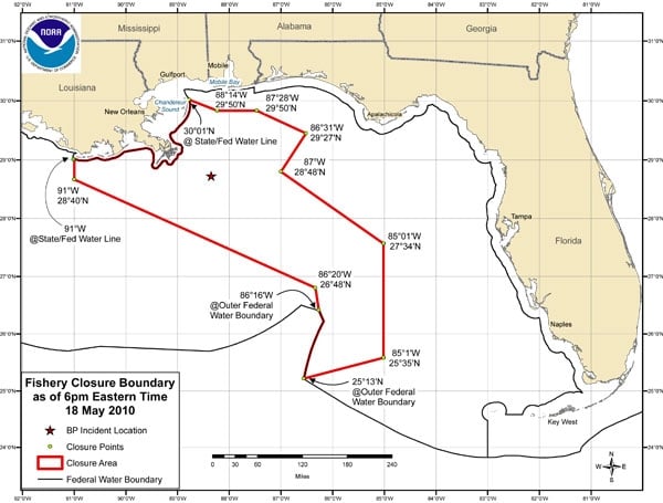
Revisions to the area in the Gulf of Mexico that has been closed to fishing in response to the Deepwater Horizon well-head blowout will take effect on May 18, 2010 at 6 p.m. eastern time. All commercial and recreational fishing including catch and release is prohibited in the closed area; however, transit through the area is allowed.
The accompanying map delineates the total closure:
Regardless of the closure boundaries, NOAA advises anglers to avoid areas where oil or oil sheens (very thin layers of floating oil) are present, even if those areas are not currently closed to fishing.
A description, with coordinates, of the total revised area of closure, is posted as Fishery Bulletin FB10-40 BP Oil Spill at www.sero.nmfs.noaa.gov/deepwater_horizon_oil_spill.htm. The area measures 45,728 square miles, which represents approximately 19 percent of the Gulf of Mexico exclusive economic zone, and doubles the area that had been closed prior to this announcement.
Links for more information:
Southeast Regional Office’s Web page: http://sero.nmfs.noaa.gov
NOAA’s Fisheries Service
http://sero.nmfs.noaa.gov/deepwater_horizon_oil_spill.htm
NOAA’s National Ocean Service
http://response.restoration.noaa.gov
Deepwater Horizon
http://www.deepwaterhorizonresponse.com