While the trend toward networked architecture has driven electronics development the past several seasons, that same technology has been stuffed into some pretty small packages recently, providing the same cutting-edge gear to the smallest of fishing boats. The inshore fisherman is now far from dependent on technological table scraps. Flats boats, bay boats and center consoles designed for inshore angling are the target markets for the same powerful tools available to offshore anglers.
Chart plotters are the heart and soul of the current inshore suite. Depending on how far inshore you spend most of your time, a depth sounder may or may not be a critical component of the unit on the console. But it’s a cinch that the farther inshore you go and the trickier the navigating, the more important the plotter element becomes.
Here are some of the best units available to help you catch more fish and get around more easily and safely.
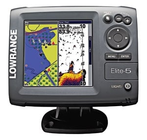
Lowrance’s new Elite series includes three 5-inch waterproof color displays: the Elite-5x fish finder ($449), Elite-5m chart plotter ($499) and Elite-5 fish finder and chart plotter ($549). Plotter models have a built-in GPS with an external antenna option, a preloaded U.S. base map showing soundings and contours out to 1,000 feet, and a micro Secure Digital memory-card slot for the addition of Navionics Gold cartography. Fish finder models feature a transom-mount 83/200 kHz Skimmer transducer with 120 degrees of coverage and a temperature sensor. The TrackBack function allows scrolling back to review display history.
Also new, the Lowrance Mark series of fish finders includes two 5-inch models: the dual-frequency Mark-5x Pro ($199), with 120 degrees of sonar coverage down to 1,000 feet, and the single-frequency 200 kHz Mark-5x ($159), which operates down to 800 feet and provides up to 60 degrees of coverage, when inshore depths are your only concern.

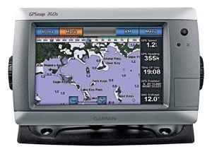
Garmin’s GPSMAP 700 series has the first 7-inch stand-alone touch-screen chart plotter with radar capability and built-in sonar scaled especially for single-station fishing boats. Radar may be less than critical for a lot of inshore angling, but this series is ready for easy integration if you get the urge to fill some of that space on the T-top with a radome. The GPSMAP 740 ($1,399.99) comes preloaded with detailed offshore maps for all U.S. coastal areas, including Alaska and Hawaii, and Explorer Charts data of the Bahamas. The GPSMAP 740s ($1,499.99) adds a 1 kW-capable sonar transceiver. Both offer full NMEA 2000 connectivity.
The GPSMAP 546 compact chart plotter ($999.99), with a traditional keypad is a high-res, superbright 5-inch color display sized to perch on the console of the smallest skiff with high-speed drawing and panning. It’s ready to go with a satellite-enhanced base map preloaded with U.S. coastal areas, including Alaska and Hawaii, and detailed charts for the Bahamas, and it accepts BlueChart g2 Vision cards. The GPSMAP 546s adds a sounder to the mix and is NMEA 2000 certified.
Expanding on an impressive list of sonar capabilities, Humminbird recently announced the new 800 series fish finders, which now have a new twist: Down Imaging sonar to complement the Side Imaging technology featured in the 7-inch 898c SI Combo ($1,499.99). Down Imaging adds photolike imagery of the bottom directly beneath the boat, providing a detailed look at structure and the water column. Combined, Down Imaging and Side Imaging give a detailed 180-degree view beneath the boat. Both the aforementioned unit and the 858c Combo ($999.99) incorporate dual-mode SwitchFire sonar: Max Mode reveals details, including plankton, thermoclines and current, and it even tracks lures. On Clear Mode, the return is filtered to display fish and structure only, for a clean image, especially useful for reducing clutter caused by turbulence. Both models are preloaded with ContourXD by Navionics and upgradable to Navionics Platinum+, Gold, HotMaps and HotMaps Premium packages.
Furuno brings all of the high-end charting of the networked NavNet 3-D to a self-contained unit sized for inshore fishermen with the MFD8 ($3,595). It’s preloaded with a NOAA raster chart library for the U.S. coastline, including Alaska and Hawaii. TimeZero allows instant redraw, zoom and pan, with no lag time, in full 3-D chart rendering. Satellite photography fuses with raster or vector chart information to illustrate varying depths by a gradient in overlay transparency while still displaying underlying chart data. It’s fully compatible with Furuno’s Ultra High Definition digital radar and AIS.
Variable rotation speed drives dual-range radar, which displays two separate radar ranges simultaneously. Tide and current tables are preloaded, and the unit comes complete with engine monitoring, which can be configured with the addition of the appropriate sensors. For those who have a Sirius receiver and subscription, Sirius Satellite weather overlays charts. In short, the MFD8 packs the sophistication of Furuno’s flagship product into a self-contained package sized for inshore fishing boats.
The A-Series chart plotter and fish finder combos from Raymarine bring the power of the company’s big guns into the inshore cockpit with the 5-inch A50D (starting at $999). This powerful yet compact system incorporates Raymarine’s HD Digital fish finder technology and throws it on a direct-sunlight-viewable high-resolution 5-inch VGA color display. The unit’s rugged waterproof construction makes the A50D a perfect fit for center consoles and other vessels that have open cockpits. All A-Series models feature preloaded charts for coastal or inland waters, along with a CompactFlash reader for optional chart cards, a built-in GPS sensor, waterproof construction and a quick-release swivel-mounting tilt bracket.


